
Auktion
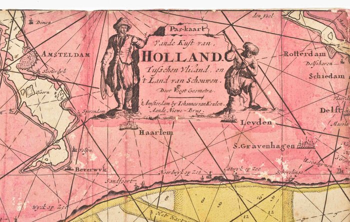
Seekarte der holländischen Küste, 1690

1 EUR
Details
Datum:
16/10/2024
Material:
Papier
Farve:
Gelb
Beschreibung vom Verkäufer
Seekarte der holländischen Küste, 1690
Pas-kaart vande Kust van Holland, tusschen Vliland en 't land van Schouwen. Indgraveret søkort af Claes Jansz. Vooght, Geometra. Udgivet af Johannes van Keulen, Amsterdam, ca. 1690. 57 x 25 cm. Monteret på pap af moderne bruger og moderne håndfarvning. Mangler en lille del langs højre kant. Nogle skader/pletter. Stadig et pænt, tydeligt brugt eksemplar. Meget sjældent søkort, ingen andre kopier sporet.
Papier
KORT
Gelb
Menge: 1
mål: 57 x 25 cm
Ähnliche Produkte
Ähnliche Produkte
Ähnliche Produkte
Ähnliche Produkte
Ähnliche Produkte
Ähnliche Produkte
Ähnliche Produkte
Ähnliche Produkte
Ähnliche Produkte
Ähnliche Produkte
Ähnliche Produkte
Ähnliche Produkte
